Page 1 of 1
Paulins Kill - Are There Fish in This Section?
Posted: Sun Sep 20, 2020 10:39 am
by Luke_M310
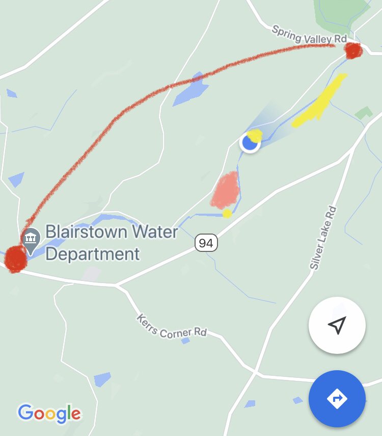
- 004BF212-C8A7-4127-9652-FD5CECEBE7C6.jpeg (278.61 KiB) Viewed 25131 times
Walked a relatively short stretch of the Paulins Kill Valley Trail this morning. Started at the lake near the Blairstown Water Department, and turned around once I reached Spring Valley Road. An elementary school level map Is attached showing my path.
First and foremost question - are there fish in this section? There are definitely some areas that “look” worthwhile once you get above the still water near the lake.
Second - you will see that I used Yellow in the attached map to show where I saw POSTED signs on the river side of the trail. You can see two very random signs that are the yellow “dots,” as well as a consistent section posted by the Paulins Kill Property Owners Association. That stretch is consistent, at least. The two random signs left me puzzled.
There’s also a “peach” area of the map that shows a cut-out patch of land off the trail that also had one single (very worn out) POSTED sign. I walked through it anyways, got down to the river, and did see another NO TRESPASSING sign once I got to the water. Anyone know anything about this patch of land? It almost looks like it was once a growing ground for something.
Forgive me if any of this is out of bounds, I know talking about spots can be sensitive. I’ll take this down, if requested, or feel free to take it to my PM’s. Honestly, I’m just a dumb guy trying to figure out areas that hold fish that I can legally fish in.
Re: Paulins Kill - Are There Fish in This Section?
Posted: Sun Sep 20, 2020 10:30 pm
by BiggerThomas
Locate public access on a tax map and find out for yourself.
Re: Paulins Kill - Are There Fish in This Section?
Posted: Mon Sep 21, 2020 11:57 am
by Luke_M310
Ok, let's just take this down. I don't want to this left up if I'm asking the wrong questions. Was just curious.
I'd do it myself but the option to edit or delete the original post doesn't seem to be available.
Re: Paulins Kill - Are There Fish in This Section?
Posted: Mon Sep 21, 2020 4:00 pm
by SBRtool
Can't speak to if there's any good fishing in that section cause I'm not familiar with it but by looking at tax maps, it looks like just about all of that stretch is fishable from one side or the other. Most of the northern bank is owned by NJ DEP land and some of the southern bank but there is some private property on both sides it looks like.
Re: Paulins Kill - Are There Fish in This Section?
Posted: Mon Sep 21, 2020 8:09 pm
by Troutman
what type of fish are you looking for

. Im familiar with that section

Re: Paulins Kill - Are There Fish in This Section?
Posted: Mon Sep 21, 2020 9:05 pm
by Luke_M310
Troutman wrote: ↑Mon Sep 21, 2020 8:09 pm
what type of fish are you looking for
. Im familiar with that section
Anything a fly rod can catch would be acceptable to me.
Re: Paulins Kill - Are There Fish in This Section?
Posted: Tue Sep 22, 2020 4:26 pm
by Troutman
Luke_M310 wrote: ↑Mon Sep 21, 2020 9:05 pm
Troutman wrote: ↑Mon Sep 21, 2020 8:09 pm
what type of fish are you looking for
. Im familiar with that section
Anything a fly rod can catch would be acceptable to me.
forget about that section for trout unless they will be a recent stocking. The native fish there are suckers & sunfish off season

Re: Paulins Kill - Are There Fish in This Section?
Posted: Tue Sep 22, 2020 8:47 pm
by PortMurrayAng
SBRtool wrote: ↑Mon Sep 21, 2020 4:00 pm
Can't speak to if there's any good fishing in that section cause I'm not familiar with it but by looking at tax maps, it looks like just about all of that stretch is fishable from one side or the other. Most of the northern bank is owned by NJ DEP land and some of the southern bank but there is some private property on both sides it looks like.
What do you look for in tax maps for access?
Re: Paulins Kill - Are There Fish in This Section?
Posted: Tue Sep 22, 2020 11:00 pm
by dbarr15
Are the tax maps available online for free? Link please
Re: Paulins Kill - Are There Fish in This Section?
Posted: Thu Sep 24, 2020 12:37 pm
by Rusty Spinner
dbarr15 wrote: ↑Tue Sep 22, 2020 11:00 pm
Are the tax maps available online for free? Link please
Here you go:
https://newjersey.maps.arcgis.com/apps/ ... 97d233fbbc
What you are looking for is public ownership versus private ownership. That said, the Paulinskill is a put and take trout fishery due to the dams that warm that river too much. But it has smallies in season and stocked trout at other times. I'm sure you can add rock bass, sunfish, largemouth, etc. in places. Much further upstream it has native brookies.